Entrance to the Union Hotel Beer Hall, Main and B streets, c. 1892, with the saloon proprietor John Hermer most likely the man with the white beard (Sonoma County Library)
In 1852, two brothers from Germany, Herman and John Schierhold, purchased a lot at the southwest corner of Main Street and today’s Western Avenue. Using timber they hauled down from Freestone, they built a two-story hotel. A classic German “gasthaus,” it included a bar and billiards room on the bottom floor, with six rooms upstairs for boarders and guests upstairs.[1]
The Schierholds’ gasthaus became an anchor for Petaluma’s growing German merchant district. By the mid-1870s German-owned businesses extended along the west side of lower Main Street from Western Avenue to Center Park (today’s Historic Chinatown Park).
They included Heinrich Matthies’ Continental Hotel and John Pfau’s Centennial Building (today’s Land Mart), which featured a German saloon, a livery stable, Heinrich Dortmund’s Wine Depot, and the German Druids Hall.
German-owned Continental Hotel and beside it the Centennial Building, 1890s (courtesy of Dan Brown Collection)
Two blocks away on Fourth Street between B and C streets sat Turn Verein, or Turner Hall, which served as a German social club, hosting lectures, social events, dances, festivals, and musical performances.[1a]
Turn Verein or Turner Hall at Fourth Street between B and C streets, built 1875 (Petaluma Historical Library & Museum and Petaluma Courier)
In 1855, the Schierholds sold their gasthaus to a woman named Rosanna Loftus who renamed it the Farmers’ Hotel. A married woman, Loftus purchased the hotel as a “sole trader,” which meant she was legally able to own and operate her own business independent of her husband.[2]
1855 map with arrow pointing to site of Farmers Hotel (Sonoma County Library)
Herman Schierhold went on to operate the Relief Saloon and the Capitol Saloon in town, as well as the Petaluma Brewery. The first brewery in Sonoma County, it was originally founded in 1855 by a fellow German immigrant, Fredrick Christlich.[3]
In 1858, a German named August Starke purchased the Farmers’ Hotel from Loftus, renaming it the Union Hotel & Saloon.[4] In 1866, he leased out operation of the hotel and saloon to Heinrich Matthies, who added “Deutsche Gasthaus” to the name Union Hotel.[5]
Illustration of the Union Hotel, Deutsche Gasthaus, 1885 (Map of Petaluma by William W. Elliott, Sonoma County Library)
In 1876, Petaluma’s leading capitalist John McNear purchased the hotel building and property from Starke’s widow, Frances.[6]
In 1881, McNear sold the Union Hotel building to fellow capitalist Isaac Wickersham, who moved it to property he owned at the southeastern corner of Main and B streets. That cleared the way for construction of the Masonic Lodge at the hotel’s original site on the corner of Main and Western Avenue.
Masonic Lodge at Main Street and Western Avenue, 1902 (Petlauma Historical Library & Museum)
Meanwhile, Wickersham undertook a complete rebuilding of the hotel in its new location, adding 17 new rooms.[7]
In 1889, the description “Deutsche Gasthaus” was dropped from ads for the Union Hotel by longtime operator Samuel Carstens, a Danish immigrant A German named John Hermer ran the Union Beer Hall in the hotel.[8]
Ad for Union Hotel Beer Hall, Petlauma Courier, May 24, 1892.
In 1900, a fire, suspected to be arson, badly damaged the hotel, destroying its bar and bowling alley. By that time, the hotel was owned by G.P. McNear, who leased it to Claus Struve, a German immigrant, and Jimmie Rasmussen, a Danish immigrant.[9]The hotel was restored and reopened.
In 1902, G.P. McNear’s Oriental Mills & Feed headquarters on Main Street across from Penry Park (then Hill Plaza) burned down. McNear decided to relocate his operation to the site of the Union Hotel, which sat in front of one of his grain mills (today’s Great Petaluma Mill).
He announced plans to move the Union Hotel to Third streets and C streets so that he could clear the site for his new building. A few months later, he changed his mind, and decided to tear the hotel down instead.[10]
New G.P. McNear Feed Company Building, 1903 (Petaluma Historical Library & Museum)
So ended the legacy of a 50-year old Petaluma landmark building.
FOOTNOTES:
[1] “Local News As Condensed,” Petaluma Argus, October 3, 1902; “Built the Union Hotel,” Petaluma Courier, October 3, 1902; Note: no mention of the name of the Schierholds’ hotel found.
[1a] “Cosmopolitan Hotel,” Petaluma Argus, August 25, 1876; “Pfau’s Centennial Building,” Petaluma Argus, March 3, 1876; “Centennial Headquarters,” Petaluma Argus, July 14, 1876; “The Druids,” Petaluma Courier, December 22, 1880; “Turners’ Ball,” Petaluma Argus, January 1, 1875.
[2] Legal Sole Trader Notice, Petaluma Journal, September 22, 1855; Ad for Farmer’s Hotel, Petaluma Journal, November 20, 1855; Note: not clear if Schierholds were the owners at time of sale to Loftus.
[3] “Courierlets,” Petaluma Courier, October 22, 1884; “H. Schierhold Died Weeks Ago,” Petaluma Argus, December 22, 1905; “Petaluma Breweries,” Petaluma Argus, December 8, 1876; Note: Christlich launched the brewery with a partner named Erbe, who by 1860 had sold out his interest to Christian Theilman, who died in 1864.
[4] Ad, Sonoma County Journal, February 12, 1858: Starke converts Farmer’s Hotel to Lager Beer Saloon; “Brutal,” Sonoma County Journal, February 11, 1859: Starke’s establishment now referred to as the “Union Billiard Saloon”; Ad for Union Hotel, Sonoma County Journal, October 12, 1860.
[5] Ad for Union Hotel, Petaluma Argus, September 6, 1866. Note: by the 1870s, Matthies was also operating the Continental Hotel (“Cosmopolitan Hotel,” Petaluma Argus, August 25, 1876).
[6] “Brevities,” Petaluma Argus, October 20, 1876; “Real Estate Transactions,” Petaluma Argus, November 3, 1876.
[7] “City Improvements,” Petaluma Courier, June 1, 1881; “Housewarming,” Petaluma Argus, August 19, 1881; “Reopened,” Petaluma Courier, August 31, 1881; Ad for Union Hotel, Petaluma Argus, September 30, 1881.
[8] Last ad for Union Hotel including “Deutsche Gasthaus,” Petaluma Courier, January 30, 1889; Ad for Union Beer Hall, Petaluma Courier, May 24, 1892; “John Hirmer Dead,” Petaluma Courier, May 31, 1894.
[9] “The Union Hotel Badly Wrecked,” Petaluma Argus, July 9, 1900.
[10] “A Midnight Blaze,” Petaluma Courier, June 11, 1902; “Union Hotel to Be Moved to Third and C Streets,” Petaluma Argus, August 15, 1902; “Local News As Condensed,” Petaluma Argus, October 3, 1902.
Petaluma’s Main Street looking north from Western Avenue, 1930 (photo courtesy of Dan Brown)
On September 3, 1925, an auto caravan of 40 “cavemen” clad in the skins of mountain lions, panthers and wildcats, set off from Grants Pass, Oregon, to take possession of Petaluma, California. Before departing, they made sure to book 26 rooms at the Hotel Petaluma, requesting permission to set up a cave in the lobby.1
The cavemen were bound for a convention promoting the Redwood Highway, a new auto route extending from the Oregon Caves Monument outside Grants Pass to the docks of Sausalito. The name “Redwood Highway” was coined in 1921 by A.D. Lee, a Crescent City hotelier, who believed the new scenic thoroughfare too lucrative to be designated by merely a number.2 Regardless, in 1926 it would officially become part of U.S. Highway 101.
Lee’s inspiration for the name came from a conservationist group called Save the Redwoods League, who in 1918 mounted a campaign to preserve what remained of California’s old growth redwood groves by making them state parks.3
Members of the Save the Redwoods League, 1920s(photo Humboldt County Historical Society)
The conservationists’ call of the wild spoke to a new wave of automobility sweeping the country. No longer hampered by wretched roads, the limited speed and endurance of the horses pulling wagons and stages, or the inflexible timetable of steam locomotives, motor-savvy Americans were setting out aboard their gas-powered “vacation agents” for road trips to the wildest and most natural places on the continent.4
Auto tourists on the Redwood Highway, 1920s (photo public domain)Petaluma’s Bungalow Auto Camp, 711 Petlauma Boulevard North at Cherry Street, 1928-1975 (photo Sonoma County Library)
To capitalize on the craze, Lee and a group of fellow entrepreneurs in Del Norte, Humboldt, and Mendocino counties launched the Redwood Highway Association.5 For help in convincing other counties to get on the bandwagon, Lee reached out to fellow “booster extraordinaire” Bert Kerrigan, secretary of Petaluma’s Chamber of Commerce.6
Known for putting Petaluma on the map as “The World’s Egg Basket,” Kerrigan specialized in the sort of razzle dazzle stunts that attracted filmmakers screening newsreels in movie houses across the country.
His National Egg Day was full of eye-catching visuals like the Egg Parade, Egg Queen, Egg Ball, Egg Day Rodeo of hens and horses, and a “chicken chase” down San Francisco’s Market Street accompanied by a biplane dropping chicken feathers affixed with coupons for free Petaluma eggs.7
Bert Kerrigan, Secretary of Petaluma’s Chamber of Commerce and local egg booster, 1920 (photo Petaluma Historical Library & Museum)
The opportunity to position Petaluma as one of the last civilized outposts before driving off into the woods captivated Kerrigan. He went to work convincing Petaluma merchants to be among the first to adopt the use of “Redwood Highway” in their advertising, followed by the Sonoma County Board of Trade and the mayor of San Francisco.8
By the time Lee and 150 other members of Redwood Highway Association gathered at the Hotel Petaluma in 1925, Kerrigan had been shown the door as Petaluma’s ringmaster, having bled the Chamber of Commerce dry with his flamboyant stunts.9
His Redwood Highway legacy however lived on in the steady stream of autos and “auto stages” passing through town on summer weekends, bound for what travel brochures described as “the world’s most scenic Paradise Wonderland, 100 miles of giant redwood trees, primeval, primitive, and untrammeled, with streams full of fish and woods full of game.”10
1921 map of the new Redwood Empire route (illustration courtesy of the San Francisco Examiner)
The majority of the auto tourists were from Southern California. That led the Redwood Highway Association to believe they had a shot at displacing Highway 99—the future Interstate 5 running up the Sacramento Valley—as the main trunk between San Francisco and Oregon, and raking in some of the estimated $2 million ($32 million in today’s dollars) spent at roadside attractions along the way.11
Turning to tourist conquest, they changed their name to the Redwood Empire Association.12
Brochure for Auto Stage Tour of Redwood Empire, 1928 (photo public domain)
The keynote speaker at their 1925 convention was Harvey Toy, California’s commissioner of state highways. Thanks to a recent two cent per gallon gasoline tax imposed by the state, Toy informed the group he had the funds to iron out the kinks in the Redwood Highway, making it a safe and efficient thoroughfare.13
The association’s treasurer, Santa Rosa banker Frank Doyle, who was part of a group advocating construction of a bridge across the Golden Gate, updated the group on the impact the bridge would have on tourist traffic north. To avoid becoming a bottleneck, Petaluma would need to widen its Main Street from two to four lanes.
Frank Doyle, president of The Exchange Bank(photo public domain)
The prospect gave local merchants pause. Main Street was not only the town’s main artery of commerce, but the heart of its social connections and celebrations, with ample 12 foot wide sidewalks and convenient diagonal parking lanes.
Petaluma’s Lower Main Street late 1920s, where Center Park replaced carriage hitching posts (photo courtesy of Petaluma Historical Library & Museum)
The city had bent over backwards to assimilate the automobile since its arrival in 1903, paving Main Street’s bumpy cobblestones with asphalt, converting hitching posts to parking lanes, replacing liveries and stables with garages and filling stations. But reducing the width of the sidewalks and imposing parallel parking so as to accommodate four lanes of through traffic, struck many as a death knell for Main Street.
In 1935, with construction of the Golden Gate Bridge finally underway, the chief engineer of the state highway commission, Col. John Skeggs, paid Petaluma merchants a visit. Either widen Main Street to four lanes, Skeggs told them, or else the state would reroute Redwood Highway to the flats east of town.14
The Golden Gate under construction, 1935 (photo public domain)
Merchants proposed a compromise. They were willing to reduce the sidewalk widths from 12 to 9 feet to create a center third lane for making left turns, while retaining diagonal parking.
The matter remained at a standstill until May 1937, when the new bridge opened.
Cars lining up for the Sausalito ferry at Hyde Pier, San Francisco, 1937 (photo public domain)
The flood of through traffic the first two weekends convinced merchants they had no choice but to surrender to the motoring hordes of the Redwood Empire, converting Main Street to four narrow lanes and parallel parking.15
Main Street looking south from Washington Street, 1950 (photo Petaluma Historical Library & Museum)
Twenty years later, Kerrigan’s two lingering Petaluma legacies came to an abrupt end. The advent of poultry-raising factory farms throughout the country emptied the Egg Basket of the World, and the Redwood Highway abandoned Petaluma’s sluggish Main Street for the breezy new U.S. 101 freeway constructed east of town in 1957.
Into the vacuum poured thousands of auto commuters, who, thanks to the new freeway and Golden Gate Bridge, found San Francisco within easy driving distance from Petaluma. As the ranchlands east of town began filling up with suburban tract homes, Petaluma found itself transformed into a bedroom community.
While the new freeway alleviated through traffic on Main Street, it also dealt a blow to the hotels, restaurants, bars, and gas stations that catered to it. In an effort to attract freeway travelers, in 1958 the city changed the name of Main Street to Petaluma Boulevard North. Third Street, which extended from B Street to the new freeway entrance south of town, was renamed Petaluma Boulevard South.16
It wasn’t enough. New shopping malls on the eastside drained the downtown of foot traffic. By the 1960s, Petaluma Boulevard was pockmarked with empty shops and old, dilapidated buildings, forcing the city to impose an ordinance requiring owners to bring them up to code or else tear them down.17 Many chose the latter.
Boards on the windows of Wickersham Building on Petaluma Boulevard North, 1970s (photo Sonoma County Library)
In 1969, the city put before voters an urban renewal proposal calling for the demolition of all the buildings on the east side of Petaluma Boulevard from B to Oak streets, for the installation of a six-lane thoroughfare. Voters rejected it.18
In the mid-1970s, the city turned to historic restoration as a means of reviving the downtown, beginning with the Great Petaluma Mill, an abandoned grain mill downtown converted by Skip Sommer into a gallery of boutique shops and restaurants.
Great Petaluma Mill’s B Street entrance, 1978 (photo Sonoma County Library)
In a town besieged by homogenous housing developments, garden-variety business parks, and uniform chain stores, the unique character of Petaluma’s historic downtown proved the catalyst of its rebirth as a trendy nightlife and shopping district.19 That brought with it increased traffic and accidents, most of them sideswipes of parked cars due to Petaluma Boulevard’s inherently narrow travel and parking lanes.20
In 2003, city planners proposed a traffic calming measure known as the “road diet.” Much like the city’s 1935 compromise proposal, it called for reducing the number of travel lanes from four to two, with a center third lane for making left turns.21
But unlike in 1935, many merchants opposed it, worried it would reduce downtown traffic. Like a gradual approach to healthy eating, the city administered the road diet in three stages, beginning in 2007 and 2013, with the final stage along Petaluma Boulevard South scheduled for completion in fall 2022.22
Studies show the road diet has reduced collisions while maintaining the same level of pre-diet traffic, meaning that, a century after Kerrigan surrendered Main Street to the traffic of the Redwood Highway, Petaluma has finally recaptured the pedestrian-friendly heart of its downtown.23
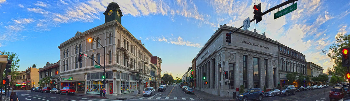
Petaluma Boulevard today with road diet (photo courtesy of Scott Hess)
******
A version of this story appeared in the Petaluma Argus-Courier, July 22, 2022
FOOTNOTES
[1] “Men to Boost Highway Here,” Petaluma Courier, August 29, 1925; “Oregon Cavemen Coming, Bringing Their Own Cave,’” Petaluma Argus, September 2, 1925; “Will Stop at Hotel Petaluma,” Petaluma Argus, September 2, 1925.
[2] The basic routing for what became “Legislated Route Number 1” was defined in the 1909 First Bond Act, as part of a route from San Francisco to Crescent City. It was extended to the Oregon border by the 1919 Third Bond Act. Ground was broken for the route in August 1912. LRN 1 corresponds to present-day US 101 and US 199, which were assigned in 1926, between the Golden Gate and the Oregon border. https://www.cahighways.org/ROUTE001.html#LR001; “Redwood Highway Suggested for Hiway,” Petaluma Courier, July 11, 1921; A.D. Lee referred to as the “Father of the Redwood Highway”: “Officers are Elected by Highway Assn.,” Petaluma Courier, October 25, 1925; “Wanted—A Dozen More, The Del Norte Triplicate, March 26, 1920.
[3]“Redwood Highway Opens Vast Scenic World to Autoist,” San Francisco Examiner, July 21, 1921; Save the Redwoods League website, https://www.savetheredwoods.org/about-us/mission -history/
[4] Peter J. Blodgett, “How Americans Fell in Love With Taking Road Trips,” Time magazine, August 15, 2015. https://time.com/3998949/road-trip-history/
[5] The seven counties officially formed the North of Bay Counties Association to promote the highway, of which the Redwood Highway Association appears to have been a subsidiary, referenced as early as February 1922; “Great North of Bay Development Program Outlined at S.R. Session,” Santa Rosa Press Democrat, November 6, 1921; “North of Bay Association is Formed,” Weekly Calistogan, November 18, 1921; “Redwood Highway to Traverse Scenic Wonderland,” Cloverdale Reveille, January 27, 1922; “Petaluma C. of C. Urge Highway Completion,” Petaluma Courier, February 19, 1922.
[6] “C.C. Endorses Naming of State Highway and Boulevard Road District,” Petaluma Courier, September 9, 1921; “Redwood Highway Booster is Here,” Petaluma Argus, October 21, 1922.
[7] John Benanti, “The Man Who Invented Petaluma,” Petaluma Museum Association Newsletter, Spring 2013, pp. 9-10.
[8] “C.C. Endorses Naming of State Highway and Boulevard Road District,” Petaluma Courier, September 9, 1921; “Pamphlets Advertising Sonoma County and Redwood Highway,” Petaluma Courier, June 22, 1922; San Francisco Press to Boost Petaluma Egg Day and Sonoma County Fair,” Petaluma Courier, July 9, 1922.
[9] “Kerrigan Resigns as Secretary of the C.C.,” Petaluma Argus, June 4, 1924; Benanti, p. 10.
[10] “Transit Company Plans Tours on Redwood Highway,” Petaluma Courier, November 7, 1924.
[11] “North of Bay Association is Formed,” Weekly Calistogan, November 18, 1921; “Big Increase in Redwood Highway Use,” Petaluma Courier, October 20, 1925; “Redwood Highway Association Ends in Meeting with a Banquet,” Petaluma Courier, October 26, 1925;
[12] “’Redwood Empire’” is New Assn Name,” Petaluma Courier, October 3, 1926.
[14] “Parking Bar to Petaluma Projects,” Petaluma Argus-Courier, January 25, 1935.
[15] “Improved Highway Facilities,” Petaluma Argus-Courier, June 15, 1937; “Petaluma Bottlenecks Doomed,” Petaluma Argus-Courier, May 11, 1938; “Traffic Lanes are Painted,” Petaluma Argus-Courier, June 8, 1938; “Active Council Works for Petaluma Progress,” Petaluma Argus-Courier, October 15, 1938.
[16] “Old Redwood Highway Renaming,” Petaluma Argus-Courier, June 23, 1958. “Supervisors Vote to Change Name of Old U.S. 101,” Petaluma Argus-Courier, July 9, 1958.
[17] “Dangerous Building Code Action by Council,” Petaluma Argus-Courier, November 21, 1967.
[18] “Measure D is Most Vital,” Petaluma Argus-Courier, June 5, 1969; “Only One Bond Issue Survives Election,” Petaluma Argus-Courier, June 11, 1969.
[19] “Mill Played a Key Role in Downtown Revitalization,” Petaluma Argus-Courier, January 9, 1980; “Bill Murray and Mayor Putnam,” Petaluma Post, February, 2014.
[20] “Boulevard ‘Road Diet’ to Begin in September,” Petaluma Argus-Courier, August 8, 2007; “Downtown Road Diet Nixed,” Petaluma Argus-Courier, October 8, 2009.
[21] “Boost in Economy, Increase in Traffic Downtown Anticipated,” Petaluma Argus-Courier, October 8, 2003; “Boulevard ‘Road Diet’ to Begin in September,” Petaluma Argus-Courier, August 8, 2007; “Downtown ‘Road Diet’ Narrowly Approved,” Petaluma Argus-Courier, October 7, 2010.